Loading... Please wait...

Store Navigation
- Home
- Archival prints
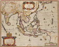
- Indiae Orientalis nec non Insularum Adiacentium nova descriptio per Nicolaum Visscher cum privilegio Ordinum Hollandiae et Westfrisiae


Product Description
First included in Jansson's Novus Atlas 1657-58, this map shows the East Indies, north coast of Australia, Carpentaria, and Nova Guinea. It shows both Cape Keerweer (13 3/4 deg. S. lat.) and Keerweer (7 deg. S. lat.). This is described by C.H. Coote (The Remarkable maps, 1895) as "attempt to place upon record the conflicting claims of the true and false Keerweers". However, a passage in the Instructions for the Frigate de Geelvink (1705) mentions both locations: "Nassauw River, past Cape Keerweer, (...) Carpentier River, Hooge Eyland, (...) Meeuen River, you will run along the bay of Keerweer (...) past the Doodslagers River". This is supplemented by Isaac De Graaf's 1705 ms. Chart of the Malay Archipelago. Therefore, both locations were discreet and in current official use by De Graaf, the Cartographer to the East India Company 1690-1714. 'Cape Keerweer' marks the extreme point of the discovered land during the voyage of the Duyfken in 1606; Carstensz (1623) names the place where his men fought with the natives on 7 March 'Keerweer' (Turnaround) "seeing that the land here trends to S.W. and West; its latitude being 7 deg."