Loading... Please wait...

Store Navigation
- Home
- Archival prints
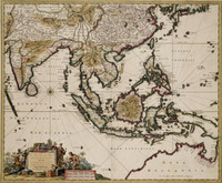
- India quae orientalis 1639


Product Description
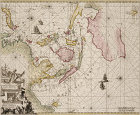
A E Nordenskioeld reproduced this map in his Facsimile-Atlas. Dating it 1599, he lists it as one of only three 16th century maps drawn on Mercator's projection. It shows India, Indonesia, South East Asia, the Phillipines, Nova Guinea, Trial, Timor, G F de Wits Land and Eendrachtland.Nordenskioeld may err in dating his reproduction 1599, as H. Hondius was born 1597, and the map includes Eendrachtland (1616) and de Wit's Land (1628).