Loading... Please wait...

Store Navigation
- Home
- Archival prints
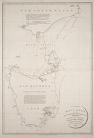
- Het Westelykste Gedeelte van t Land vande Eendragt of Nova Hollandia 1753


Product Description
Map of Western Australian coastline from Willem River to Rottnest Island, including Rottnest, Dirk Hartog, Houtmans and Dorre Islands. Relief shown pictorially, with bathymetric soundings. At head of map, within frame, "De West kost van het land van de Eendragt of Hollandia Nova." Inset: Rottnest Island, with scale in Dutch sea miles, or 15:1?. Scale: Dutch sea miles, or 15:1?; and English and French leagues or 20:1?.