Loading... Please wait...

Store Navigation
- Home
- Archival prints
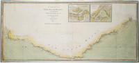
- Chart of Bass Strait between New South Wales and van Diemen's Land 1798-99


Product Description
Second state (1801) of Flinders' A chart of Basses Strait between New South Wales and Van Dieman's Land of 1800. The publisher's date remains unaltered, but spelling of "Basses" and "Van Dieman" is changed.
Shows Van Diemen's Land, Bass Strait and mainland from Western Port to Twofold Bay with information from the voyages of George Bass and Matthew Flinders. This second state anticipates King Island ("Land of considerable extent has been seen in about this situation") and provides more detail on Furneaux's Islands than the first state.