Loading... Please wait...

Store Navigation
- Home
- Archival prints
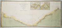
- New chart of the eastern coast of New Holland from South Cape to Cape York


Product Description
Map of the east coast of Australia showing explorers' routes. Relief shown pictorially and by bathymetric soundings. Insets: The coast of New South Wales from Cape Tribulation to Endeavour Straits showing The Labyrinth & ca on a larger scale with the tracks of Captn. Cook & Lieut. Bligh -- Adventure Bay -- Coastal profiles -Van Diemen's Land -- Sidney Cove -- Port Jackson --Botany Bay-- Entrance of Endeavour River. The inset of Van Diemen's Land "surveyed in 1798-9 by Lieut. Flinders" moves the date of publication past July 1798; mid 1800 is more probable.