Loading... Please wait...

Store Navigation
- Home
- Archival prints
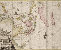
- Chart of the eastermost part of the East Indies with all the adjacent islands from Cape Comorin to Japan


Product Description
North situated to the left; the engraver's name and Seller's dedication to 'Georgius Dominus Berkley de Berkley Castro' at bottom right. First included in Seller's and Atkinson's Atlas maritimus, or A book of charts (1670?), this map was later reprinted with differently worded cartouche and with or without dedication to Berkley.
Similar to maps by Doncker, Goos, and Loon, this map was later included in Seller's Atlas maritimus, or A sea atlas (1675, 1682). Shows Indonesia, South East Asia, China, Japan, north-west Australia, southern Australian coast to Fransoys Island. Hollandia Nova shows discoveries up to Abel Tasman.