Loading... Please wait...

Store Navigation
- Home
- Archival prints
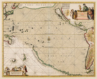
- Nuove scoperte fatte nel 1765, 67, e 69 nel Mare del Sud


Product Description
Map of Nuova Galles Merid [i.e. Australia when it was named New South Wales] and Nuova Zelanda [i.e. New Zealand] with South Pacific islands. This map is the first edition of the first decorative map to show Cook's seatracks in the Pacific. His seatrack coloured in crimson records his discoveries made during his voyage of 1769-70 in Australia, New Zealand, New Guinea and the South Pacific. Cook's charting along the east coast of Australia and New Zealand is shown in detail. The map also shows the seatracks in green of Commodore Byron with Captain Mouat in 1765 and later Samuel Wallis aboard the Dolphin partnering Phillip Carteret commanding the Swallow in 1767. The large decorative vignette in original handcolouring dominates the map - the ship depicted in the vignette is probably the Endeavour.
Imprint on map: Venezia : Presso Antonio Zatta con privilegio dell'Eccmo Senato, 1776.
Text on map: La Nuovo Galles Meridionale ovvero la Nuova Ollanda su recentemente scoperta dal Luogotenente Giacomo Cook, Comandante del Vascello di Sua Maeste Britanica, chiamato l'Endeavour, l'anno 1770 dopo avere intieramente trascorse, e girate le Coste della Nuova Zelanda.
From: Atlante novissimo / Antonio Zatta. Venezia : A. Zatta, 1779-1785.