Loading... Please wait...

Store Navigation
- Home
- Archival prints
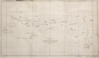
- Map of the southern hemi-sphere showing the discoveries made in the Southern Ocean up to 1770


Product Description
Original manuscript in the handwriting of Captain Cook relating to his second voyage, 6 Feb. 1772. On verso: "Captain Coo's opinion of the rout the Resolution and Adventure ought to take to explore the Southern Ocean, humbly submitted to the consideration of the Earl of Sandwich." South polar map showing tracks of Tasman 1642, Bougainville 1767, Captain Samuel Wallis (HMS Dolphin 1766-68) and the Endeavour. "Ships tracks to and from India". "Gulf of St. Sebastian - very doubtful". "Cap Circumsion [thus]". Captain Cook's proposed route of the Resolution and Adventure marked in yellow. Bound with letter and the other MS. in a volume entitled Original manuscript in the handwriting of Captain Cook relating to his second voyage. Shows 'New Zeland' and New Holland.