Loading... Please wait...

Store Navigation
- Home
- Archival prints
- Gijsbertsz Map of Africa, Asia and the East Indies 1599


Product Description
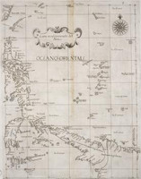
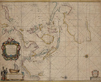
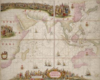
The Gijsbertsz Map is one of his three manuscript maps known. (The Koninklijke Bibliotheek holds two anonymous maps drawn on vellum attributed to Gijsbertsz because of their decorative and artistic features.) While influenced by F. Vaz Dourado's Sea Atlases with folia drawn on parchment support, Gijsbertsz used Jan Huygen van Linschoten's Itinerario (1596) as the source for his charts. It is easy to see that the individual Itinerario maps by the Langren family of cartographers, all drawn to the same scale, when grouped together would cover the area of Gijsbertsz' map. "Beach" marked on Magellanicae Pars., while Nova Guinea is subtitled Terra de Piccinacoli. This beautiful map in watercolours on parchment has a richly decorated border, and contains many group scenes, cartouches, flags, heraldic devices, compass roses, symbolic figures, inscriptions in Dutch, and Portuguese place names.