 Loading... Please wait...
Store Navigation
- Home
- Archival prints
- Historic Maps
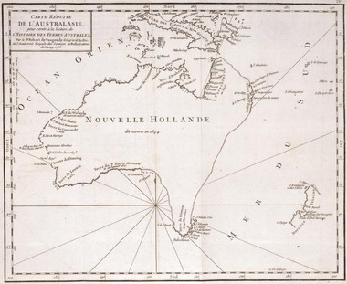
- Carte reduite de lAustralasie pour servir a la lecture de l'Histoire des Terres Australes 1756
Product Description
"Par le Sr. Robert de Vaugondy Geog. ord. du Roi de l'Academie Royale des Sciences et Belles-Letters de Nancy. 1756."
Engraved by Guillaume Nicolas Delahaye. Hypothetical east coast of Australia as in Vaugondy's Mappemonde (1752, 1756?). The 'cotes conjecturees' join the Land of P. Nuyts with Terre de Diemen, continuing upwards to 'Terre du St. Esprit' and to the tip of Carpentaria.

