Loading... Please wait...

Store Navigation
- Home
- Archival prints
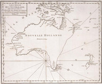
- Carte de la Terre des Papous, de la Nouvelle Guinée, et des Isles de Salomon 1774


Product Description
Map of Papua New Guinea and the Solomon Islands. Relief shown pictorially. In French.
In lower left margin: Gravé par E. Dussy. From: Voyages dans la mer du Sud, par les Espagnols et les Hollandois / ouvrage traduit de l'Anglois de M. Dalrymple, par M. de Fréville. A Paris : Chez Saillant & Nyon ..., 1774. Prime meridians: Greenwich and Ferro. Prime meridian Ferro. Also shows Cape York and the Endeavour Strait.