Loading... Please wait...

Store Navigation
- Home
- Archival prints
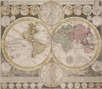
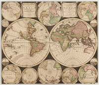
- Planisphaerium terrestre cum utroque coelesti hemisphaerio


Product Description
Double hemispherical world map showing routes of explorers including Magellan, Dampier, Tasman and Chaumont. Relief shown pictorially. In Latin. Probably from: Atlas contractus sive mapparum geographicarum. Amstelaedami : P. Schenk, [1700?] Prime meridian: Ferro. Includes twenty-six smaller astronomical diagrams and hemispheres of the world, two larger celestial hemispheres and textual commentary. Nova Guinea separated from Carpentaria; thus one of the first maps showing the Torres strait.