Loading... Please wait...

Store Navigation
- Home
- Archival prints
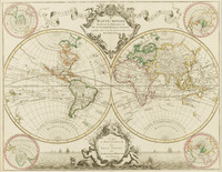
- Mappe monde ou Description du Globe terrestre vu en concave ou en creux en deux Hemispheres, 1740


Product Description
Australian mainland named "Nouvelle Hollande" and shown as incomplete coastline from "I. Saint Pierre" in the Great Australian Bight to "Hogh land" on the west coast of "Carpentarie" [ie. Cape York Peninsula], which is joined to New Guinea by partial imagined coastline. Mainland also depicted as seperate portion of coastline named "Terre Australe du S. Espirit". Tasmania named "Terre de Diemen" showing portion of southern coastline. New Zealand named "Nouvelle Zelande" with portion of coastline shown from "I. des Roys" to "Cap Cipige". Antarctica named "Terres Australes" showing incomplete imagined coastline.
Shows empires, kingdoms, states, rivers, hills, routes of explorers from 1520 to 1708.