 Loading... Please wait...
Store Navigation
- Home
- Archival prints
- Caerte van de zeylage van Iacob le Maire over de Zuydzee
Product Description
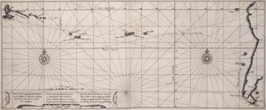
One degree latitude measures 3,3 mm. on map. Facing folio 66, Ephemerides sive Descriptio navigationis Australis institutae Anno M.D.C.XV. ductu & moderamine fortissimi Viri Iacobi Le Maire, duarum navium, quarum una Concordia, altera Cornu dicta fuit, Praefecti. Descriptio Navigationis Australis forms part of Antonio de Herrera y Tordesillas' Novus Orbis, sive Descriptio Indiae Occidentalis (Michael Colin 1622) Jacques Le Maire's voyage of discovery begun in Texel, 14th June 1615.
Proceeding via England, Madeira, Tenerife, Cap Verde, Sierra Leone, Brazilian and Patagonian coast, the ship Hoorn was lost to fire when repaired in Porto Desire. The Eendracht left alone, avoiding the Duch East Indies Company's monopoly of the Magellan Passage. Le Maire rounded and named Cape Horn, reaching Juan Fernandez in Feb. 1616.
The voyage continued along the north coast of Nova Guinea, eventually reaching Ternate and Jacatra (later Batavia) on Oct. 21st. Descriptio Navigationis Australis was also published by Colin as Spieghel der Australische Navigatie (Amsterdam 1622).
The Eendracht was impounded in Jacatra because Jan Pietersz Coen refused to believe that Le Maire discovered a new passage other than the Magellan. Guenter Schilder (Australia unveiled) asserts that Jacob Le Maire returned to the Netherlands on board Spilbergen's ship, but this is not consistent with the voyage's log entry for 31st December 1616 which notes Le Maire's death.

