Loading... Please wait...

Store Navigation
- Home
- Archival prints
- Tasman map, 1644


Product Description
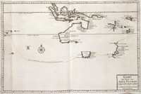
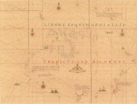
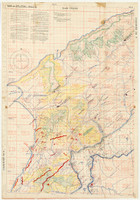
Carten dese landen Zin ontdeckt bij de compangie ontdeckers behaluen het norder deelt van noua guina ende het West Eynde van Java dit Warck aldus bij mallecanderen geuoecht ut verscheijden schriften als mede ut eijgen beuinding bij abel Jansen Tasman. Ano 1644 dat door order van de E.d.hr. gouuerneur general Anthonio van diemens.
Also known as: Bonaparte Tasman map. Tasman map 1644.
100 German or geographical miles on the graphic scale measures 6.8 cm.; 15 German miles equals one degree of latitude.
Includes inset with Mauritius, Java and Sumatra on scale ca. 1:21 568 600 showing the course of the Heemskerck and the Zeehaen in 1642 from Batavia to Mauritius and further south.
Now thought to be neither by Tasman nor from 1644, this map is important for being the only first-hand record of Tasman's route in 1644.
Ornate manuscript map on Japanese paper bought in 1891 by Prince Roland Bonaparte, and presented to the Mitchell Library by the Princess George of Greece in 1933.
Title translated: "Map these lands were discovered by the Company's explorers except for the northern part of New Guinea and the west end of Java. This work thus put together from different writings as well as from personal observation by Abel Jansen Tasman, A.D. 1644, by order of His Excellency the Governor-General Antonio van Diemen."