Loading... Please wait...

Store Navigation
- Home
- Archival prints
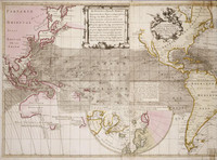
- Nova & accuratissima totius terrarum tabula nautica Variationum magneticarum index juxta observationes, left side, 1700


Product Description
New and correct sea chart of the whole world showing the magnetic variations from observations in 1700.
Shows track of Halley's ship Paramore Pink to Tristan da Cunha in 1700, when besides working on determining the longitude using variation of the compass he was also required by William lll to "attempt the discovery of what land lies to the south of the western ocean".
Later additions by R & J Ottens include Cap de la Circoncision (Bouvet Island), first shown on map by Philippe Buache 1737 (1739). Jean-Baptiste Charles Bouvet de Lozier's ships the Aigle and Marie noted here in Dutch as "scheppen d'Adelaar & de Maria". Amerigo Vespucci's landfall also shown.
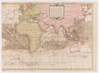
The Ottens brothers also re-issued Guillaume de L'Isle's Hemisphere Meridional (1714) in 1745, now including Bouvet's discovery.